
A guide to soils and carbon
A guide to soils and carbon
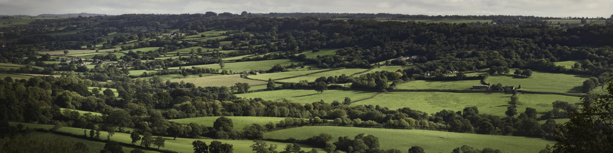
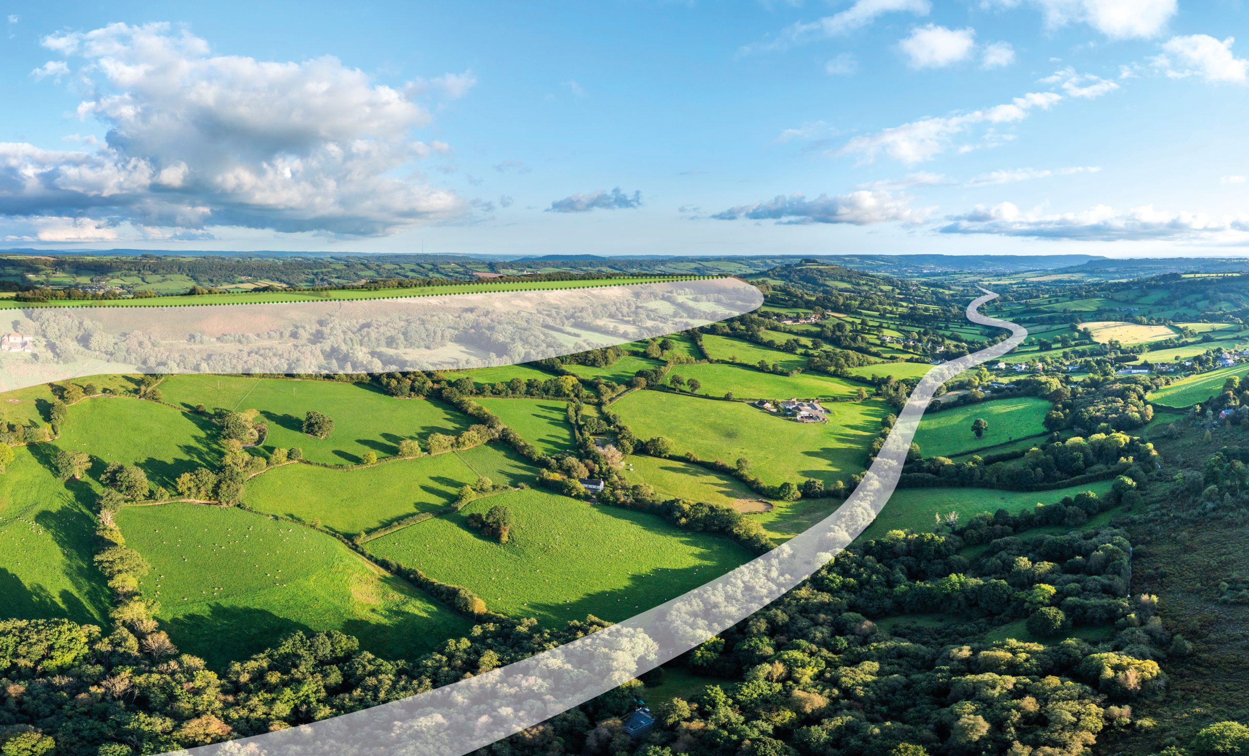
Blackdown Hills National Landscape
This guide takes you through a logical process of identifying your soils and then considering their specific management challenges and opportunities for carbon sequestration.
The guidance is informed by two studies, funded through Farming in Protected Landscapes (FiPL), which investigated the relationship between soil type, vegetation, land management and soil organic carbon (SOC). The aim was to build a local evidence base on soil carbon to support practical, landscape-specific guidance for land managers.
Download a print version
Navigating this guide
Use the links below or the contents drop-down at the top of this page to navigate the guide. You can also use your browser’s search function to quickly find specific words or topics.
Start by identifying the landscape and soil types on your land, then explore the relevant management guidance. Each section outlines common challenges, risks to soil carbon, and opportunities to manage soils more sensitively and effectively.
Introduction
Soils and carbon – the key points
What type of soil do I have?
How should I manage my soils?
Character of each soil type:
Soils and carbon in the Blackdown Hills: key points
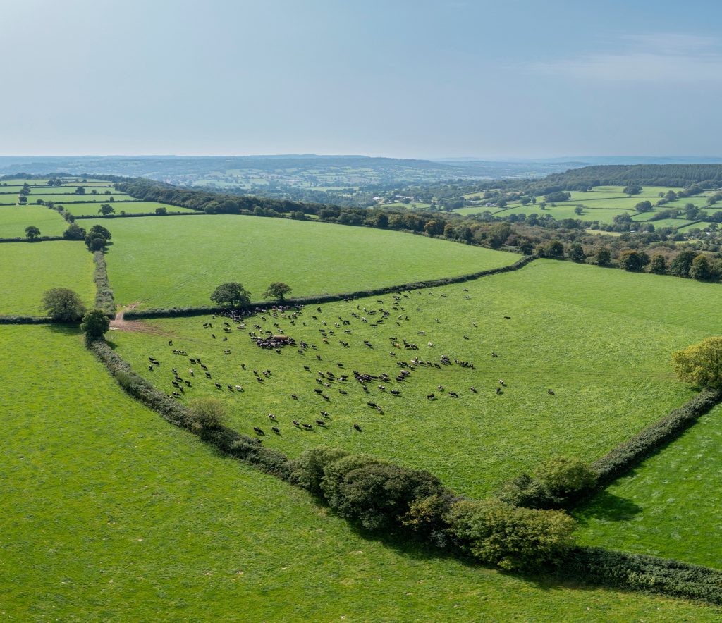
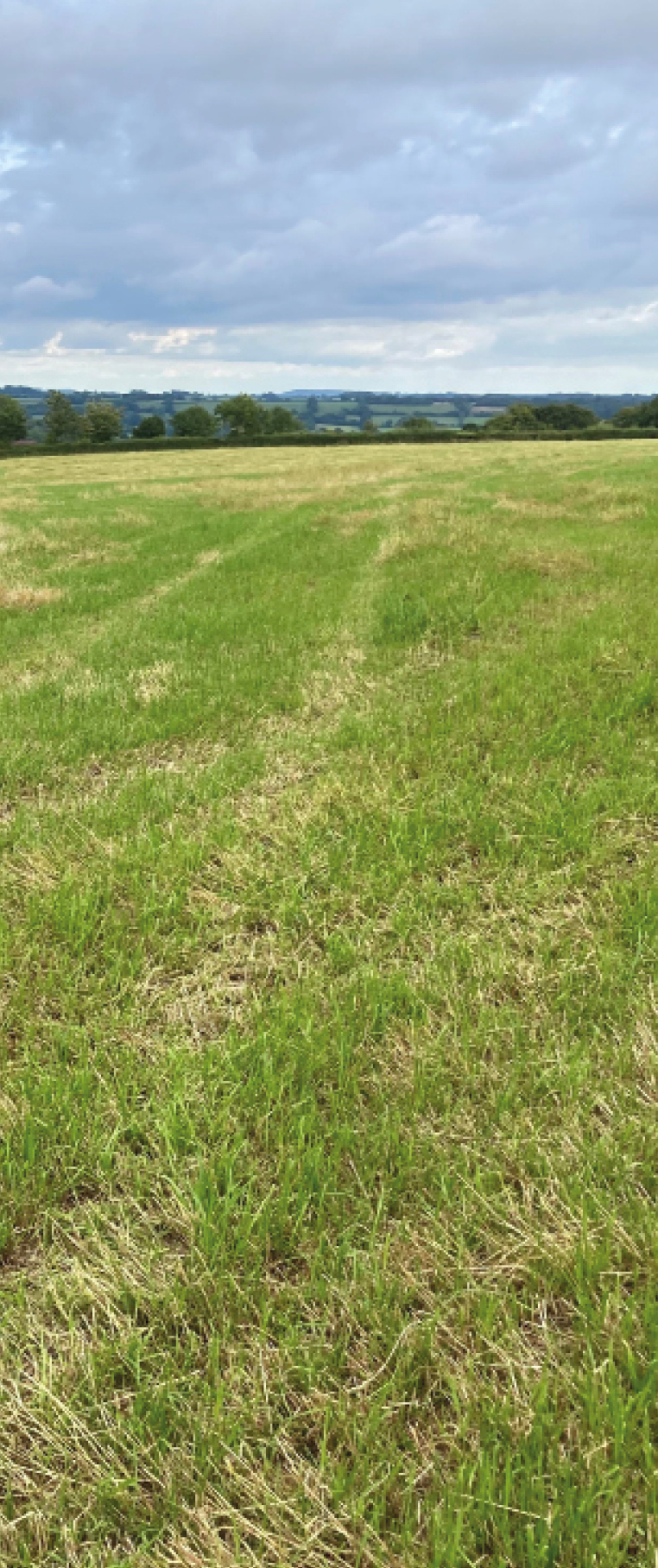
Soils across the Blackdown Hills are diverse, have different characteristics, and vary in their potential to store carbon. Understanding which soils you have is the first step to managing them in ways that protect and build soil carbon.
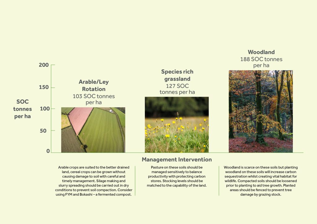
Soil carbon storage can be increased both through agricultural practices, and habitat creation or management.
Managing productive soils to store more carbon can also improve soil health and productivity.
Improving farming practices on medium brown soils (‘Whimple’ and ‘Batcombe’), can increase carbon storage over a large area.
The black, peaty ‘Blackdown’ and ‘Hense’ soil types store the most carbon per hectare.
The soils beneath mire, heath and wet woodland store the most carbon.
A focus on soil carbon can offer a triple-win, for carbon sequestration, soil health, and biodiversity.
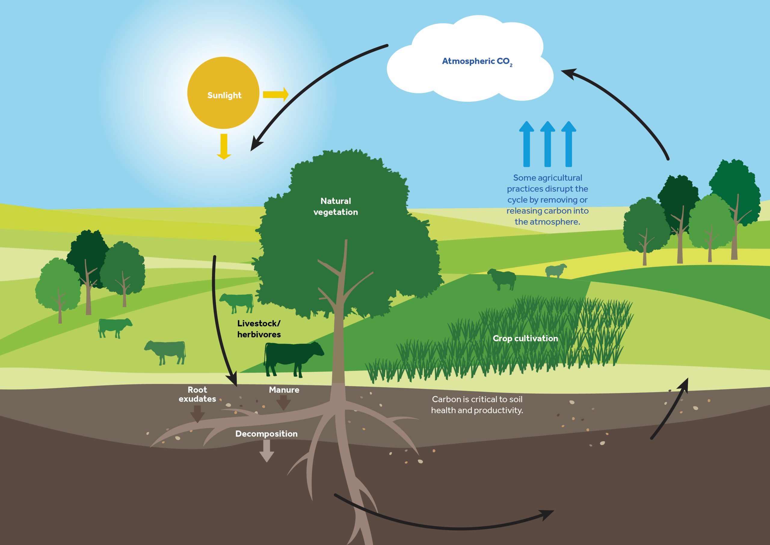
The carbon cycle
Soil organic carbon (SOC) is one part in the much larger global carbon cycle that involves the cycling of carbon through the soil, vegetation, ocean and the atmosphere.
Hover over the circles to reveal the details.
The Blackdown Hills soil map
This map is the first step in identifying your soils. Locate your land and note the landscape area it sits in, as landscape areas are often linked to different soil types.
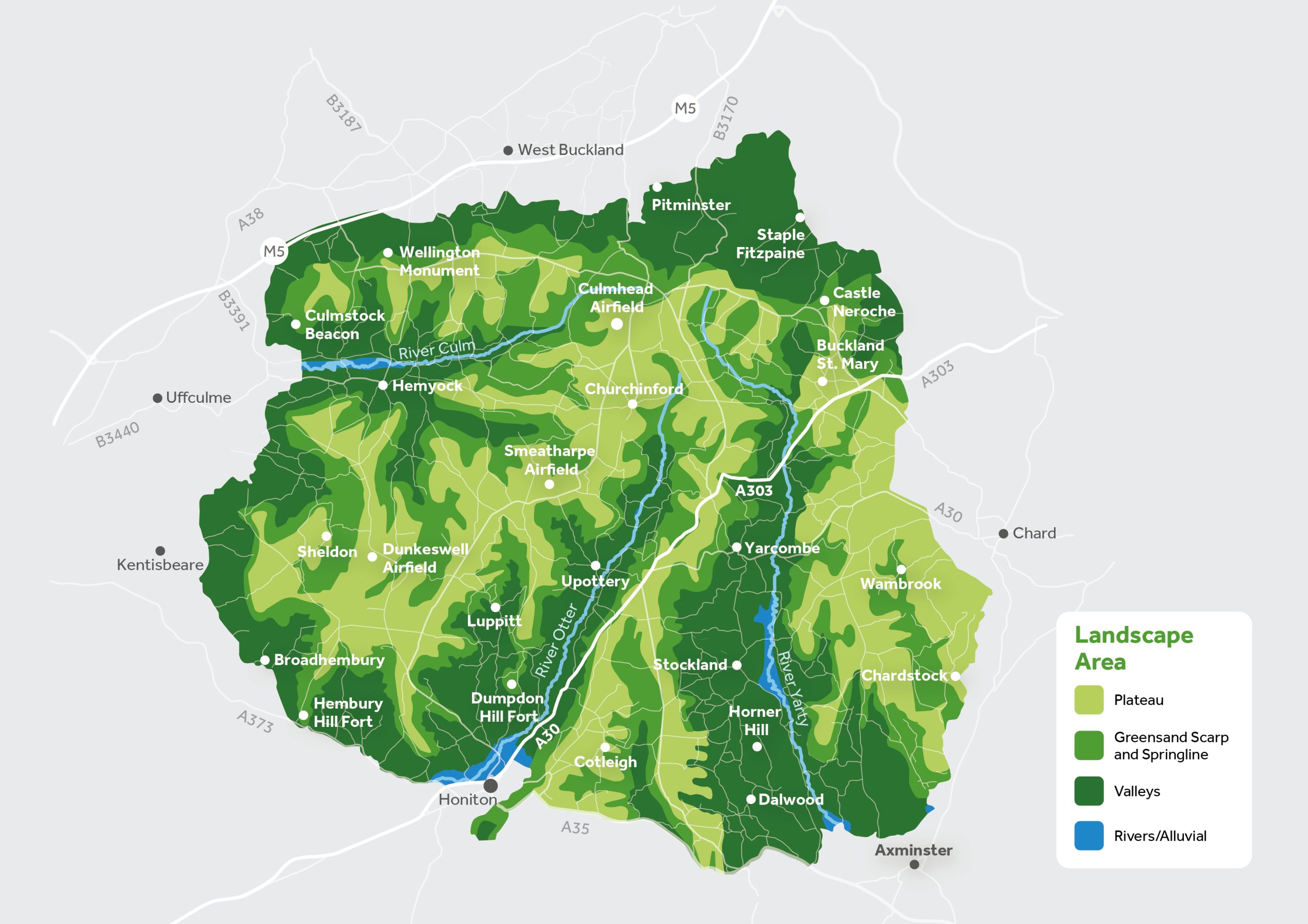
The Blackdown Hills soil landscapes
Hover over the circles to explore the different characteristics of the landscape areas in the Blackdown Hills. These characteristics help explain why certain soil types occur where they do, and are an important step in narrowing down the soils on your land.
Know your soils
This section introduces the common terms and key properties used to describe the main soil types. Use these characteristics – such as colour, texture and drainage – to help identify which soils are present on your land. You can then apply this information using the soil identification flow chart on the next page.
Alluvial soils
Found only in river valleys and flood plains, typically brown or grey, with a clay topsoil affected by groundwater.
Common Management Challenges
- Compaction
- Inundation
Peaty soils
Typically dark peaty top soil, with very high organic matter and usually wet, can be both poorly and freely draining.
Common Management Challenges
- Loss of organic matter
- Erosion
- Compaction
Light soils
Typically brown, with a sandy topsoil and free draining, occasionally poorly drained at the base of slopes.
Common Management Challenges
- Erosion (wind/rain)
- Low organic matter
- Droughty
- Steep slopes – high stone content
Medium soils
Typically brown or red, with either a clayey or silty top soil and moderately well drained, occasionally freely draining or poorly drained.
Common Management Challenges
- Erosion
- Compaction
- Soil wetness – soil erosion on slopes
Heavy soils
Typically brown or grey, with a clayey topsoil and slow draining.
Common Management Challenges
- Loss of organic matter
- Compaction
- Drainage
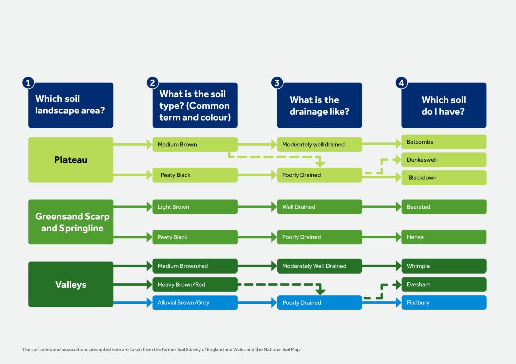
Which soils do I have?
Use this flow chart to help identify the soil types likely to be present on your land. Start with the landscape area you identified earlier, then work through the questions based on soil colour and drainage to narrow down the options.
Once you have identified your soil type, use the guide to explore its key characteristics, management challenges and opportunities for protecting and enhancing soil carbon.
Managing soil for carbon
This table summarises the key messages for each main soil group and links them to the relevant soil types. Use it to find the soil group that best matches your land, then follow the links to the detailed guidance.
| Soil types | Key points | Soils |
|---|---|---|
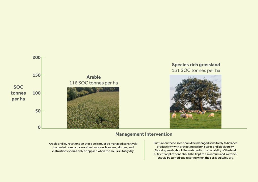
| Alluvial | Found in flood plains and frequently affected by groundwater, limiting their agricultural use to grassland. The wetness of these soils means they need to be managed sensitively, and results suggest there is a considerable uplift in soil carbon under well managed or species rich grassland. These soils can support riparian woodland which can hold high levels of soil carbon | Fladbury soils, found beside watercourses, affected by groundwater, wetness and weak bearing strength means they have limited agricultural capacity. |
| Peaty | Peaty soils store the greatest amount of carbon per ha. These soils can create a significant uplift in carbon storage, and are a priority for habitat creation and restoration. These soils are vulnerable to erosion and oxidation, potentially losing vital carbon stores, it is essential that they are managed sensitively. | Blackdown soils, found on the plateau, seasonally waterlogged and weak bearing strength, historically supported areas of wet heathland. See Soil Profiles below. Hense soils, found on the springline, almost permanently waterlogged, difficult to drain, associated with species-rich springline mire. See Soil Profiles below. |
| Light | These soils are freely draining and are found on steeply sloping areas of the escarpment. These soils have relatively limited agricultural capacity, largely grassland and woodland. Under woodland or heathland these soils have dark peaty surface and a can store large amounts of carbon. | Bearsted soils, found on the escarpment, can be very shallow and sandy, or stony, largely grassland and woodland. See Soil Profiles below. |
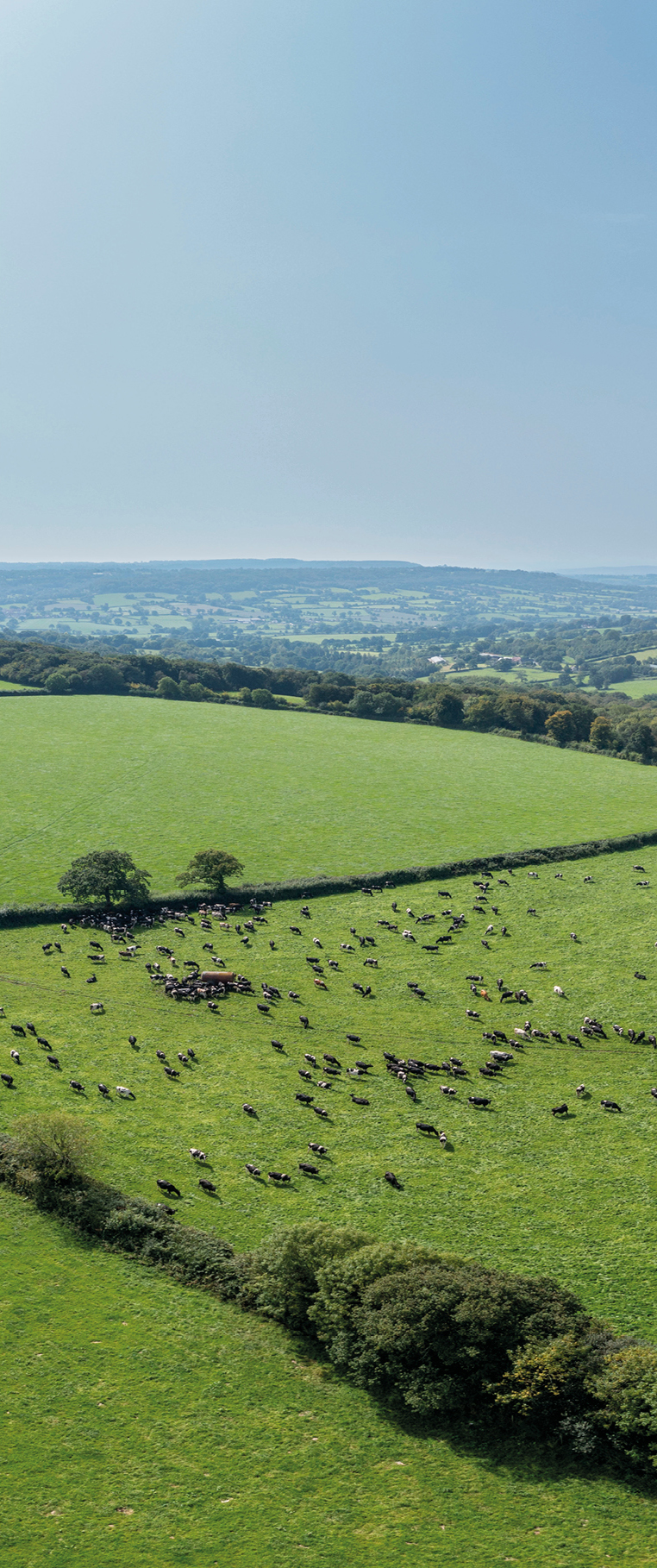
| Medium | The relative dryness of these soils means they have a greater agricultural capacity. These soils store a low amount of carbon per ha, but their large area in the landscape means they can contribute to a significant uplift in overall carbon storage. Significant uplift in carbon when arable is converted to long term grassland. | Batcombe soils, found on the plateau, driest and most productive of the plateau soils, second largest area in the landscape. See Soil Profiles below. Dunkeswell soils, found on the plateau, poorly drained and requiring drainage to support grassland. See Soil Profiles below. Whimple soils, found throughout the vales, driest and most productive of the vale soils, largest area in the landscape. See Soil Profiles below. |
| Heavy | These soils are seasonally waterlogged and heavy, reducing their agricultural capacity largely to grassland. The wetness of these soils means they need to be managed sensitively, and results suggest there is a considerable uplift in soil carbon under well managed or species rich grassland. Significant uplift in carbon when arable is converted to long term grassland. | Evesham soils, found in the vales, seasonally waterlogged, wetness and weak bearing strength means they have limited agricultural capacity. |
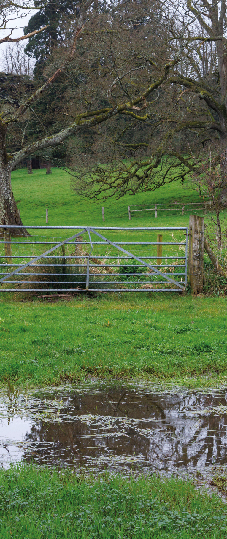
Managing alluvial soils
This section highlights common management risks and practical actions for alluvial soils. The examples below show practices that can damage soil structure and carbon, and alternative approaches that help protect soil health and carbon stores.
Positive management practices
- Grazing densities should be matched to the capability of the land. Supplementary feeding should not be carried out on wet soils and flower rich habitats.
- Silage making and slurry spreading should be carried out in dry conditions to prevent soil compaction.
- Grazing and vehicle use should be avoided in late autumn, winter and spring.
- New scrapes can be created on alluvial soils to provide flood storage areas. Woody dams and ponds can slow down flood waters. These also capture sediment and nutrients running off the wider landscape.
- In poorly drained backland, alluvial soils are most suited to grassland, hay meadows and wetland.
Negative management practices
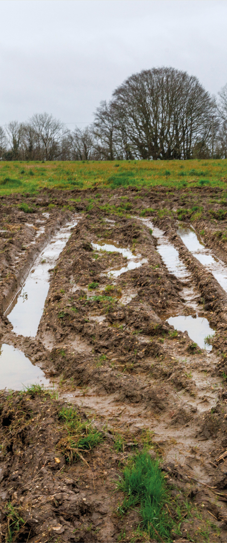
- The major limitation of these soils is poor drainage, with flooding occurring in winter, and occasionally summer.
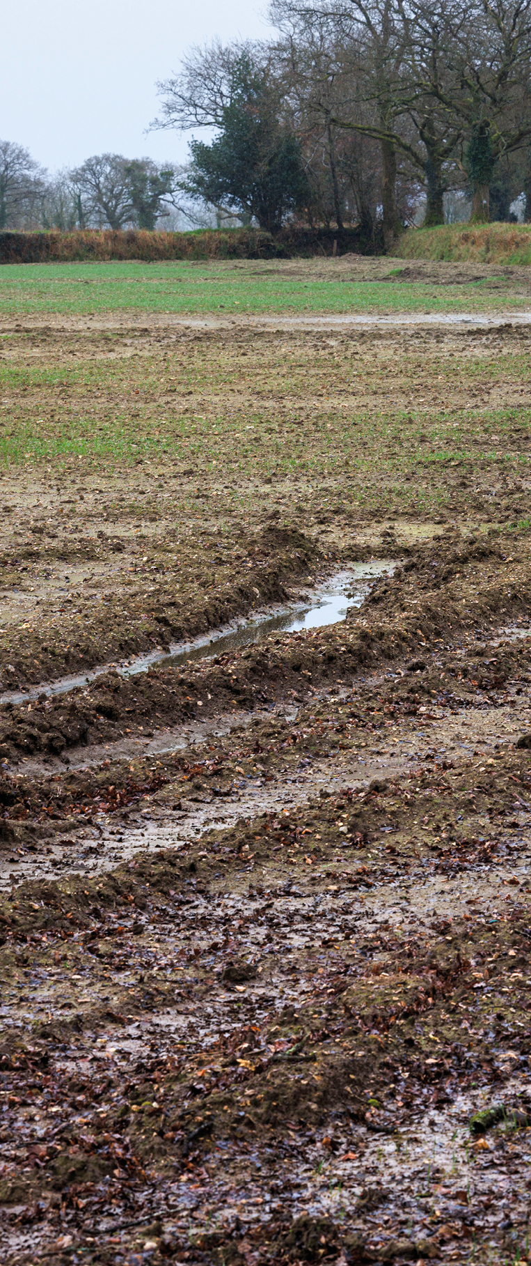
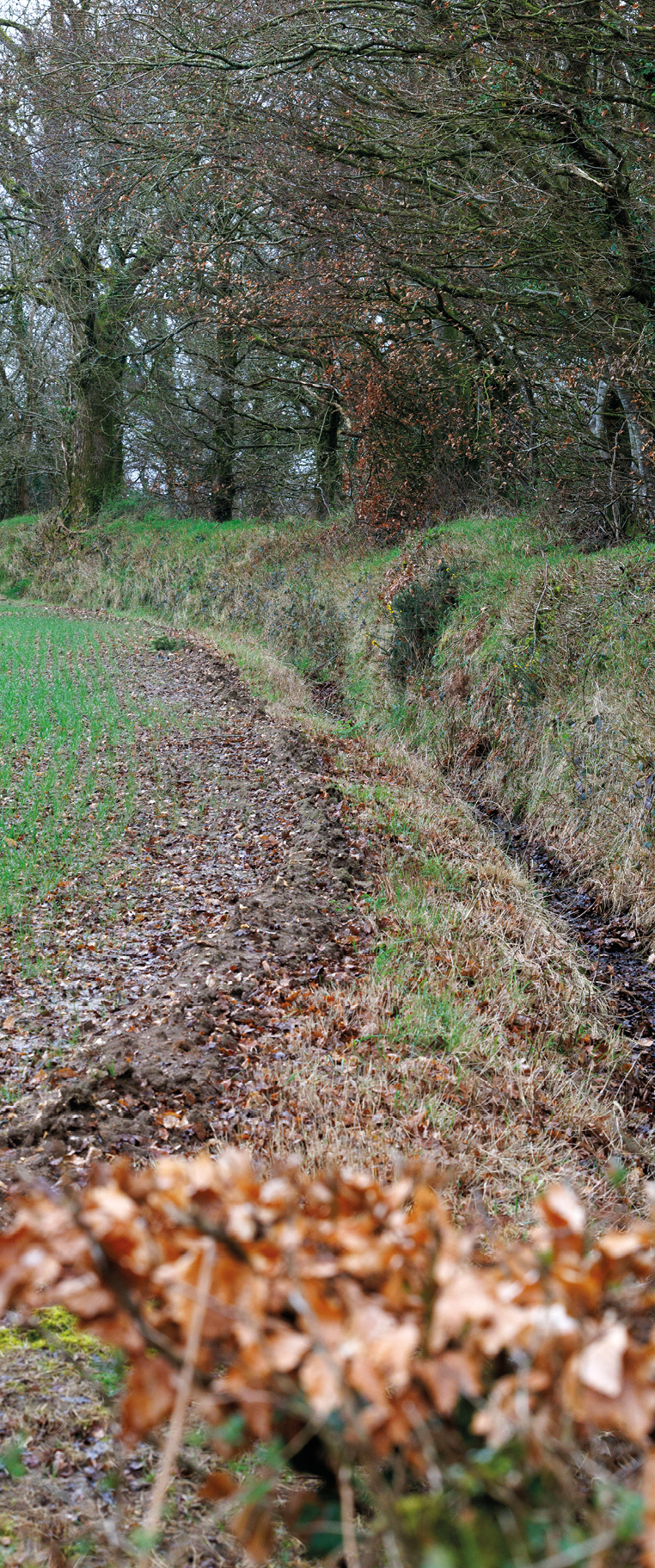
- Long periods of wetness from autumn to spring make these soils susceptible to compaction from traffic and poaching.
- Spreading slurry in winter causes serious compaction when soils are wet leading to runoff from damaged fields.
- Degraded structure and reduced porosity produces run-off causing soil erosion, flooding and sediment flowing into water courses.
- Nutrient-rich sediment in run-off clogs gravels and prevents fish spawning and affects all wildlife.
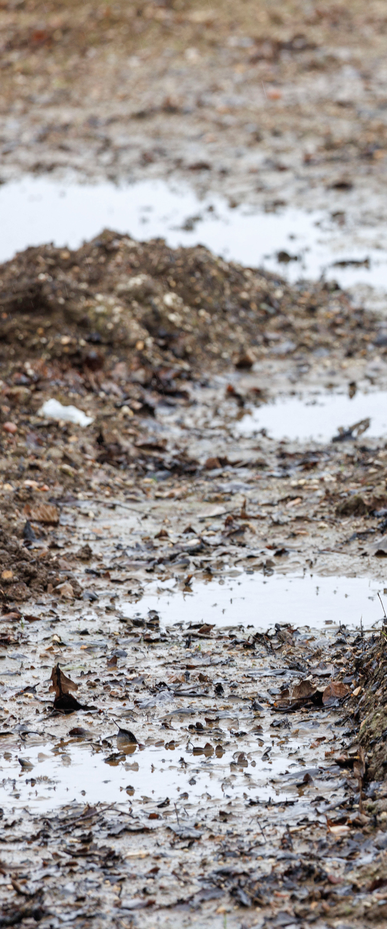
Opportunities for carbon sequestration on alluvial soils
This section highlights potential opportunities to protect and increase soil carbon for alluvial soils, based on different land uses and management approaches observed locally.
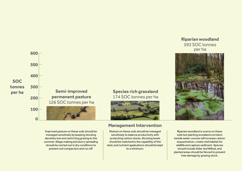
These figures have been taken from the data collected on soils during the Blackdown Hills Soil Carbon Project. View the whole dataset.
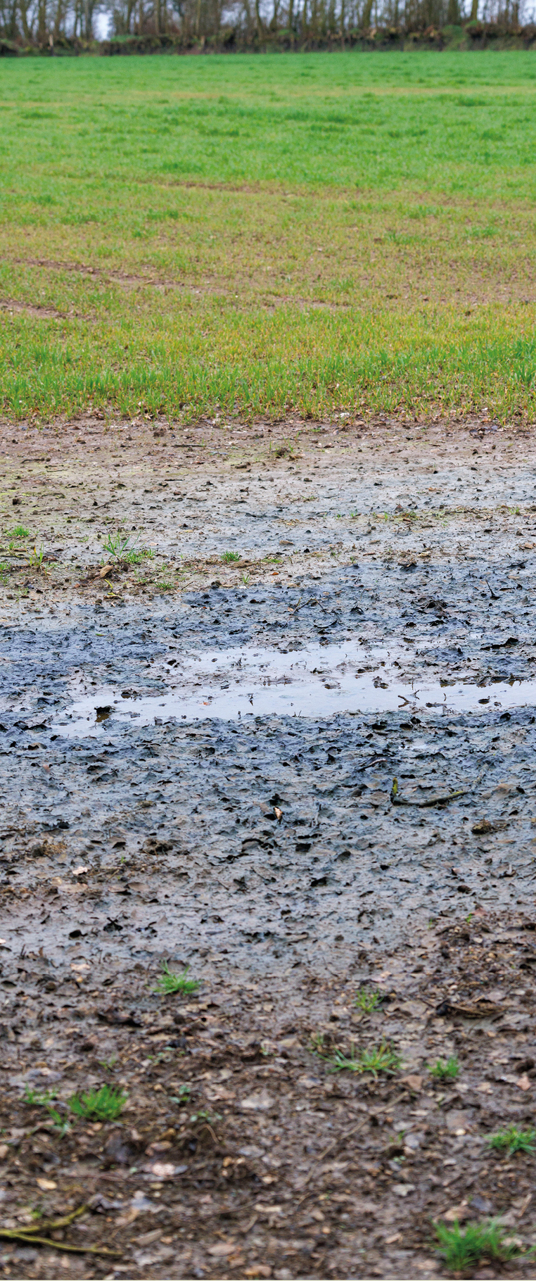
Managing peaty soils
This section highlights common management risks and practical actions for peaty soils. The examples below show practices that can damage soil structure and carbon, and alternative approaches that help protect soil health and carbon stores.
Positive management practices
- Grazing densities should be matched to the capability of the land.
- Grazing and vehicle use should always be avoided in late Autumn, Winter and Spring.
- If being used in arable or ley rotations, fields should be relatively level to reduce runoff, and soils should be loosened after harvest to remove compaction and reduce the risk of runoff.
- Earth worms can help to restore soil structure, but their numbers are significantly reduced by the impacts of compaction and waterlogging.
- Peaty soils are most suited to woodland, wetland and heathland.
Negative management practices
- Grassland soils are easily compacted and poached by overgrazing, particularly in winter months, this can be equally as damaging as the use of heavy machinery.
- Peaty soils have a weak structure and they are very easily degraded, reducing their productivity and carbon stocks.
- When drained, over cultivated or grazed peaty soils shrink and crack leaving them at risk of wind and water erosion.
- Repeated vehicle movements in fields, particularly in gateways or tracks, cause deep compaction, waterlogging and erosion which significantly reduces productivity.
- When exposed via over cultivation or grazing they are at high risk of wastage due to oxidation.
- In general, cultivation should be avoided on peaty soils as it allows the peat to waste away through oxidation.
Opportunities for carbon sequestration on peaty soils
This section highlights potential opportunities to protect and increase soil carbon for peaty soils, based on different land uses and management approaches observed locally.
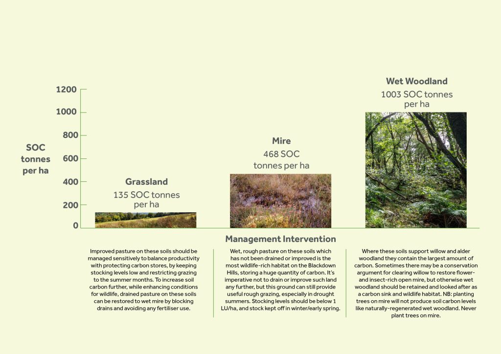
These figures have been taken from the data collected on soils during the Blackdown Hills Soil Carbon Project. View the whole dataset.
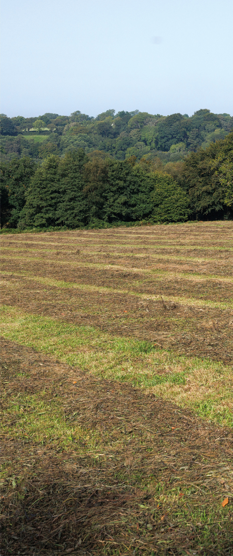
Managing light soils
This section highlights common management risks and practical actions for light soils. The examples below show practices that can damage soil structure and carbon, and alternative approaches that help protect soil health and carbon stores.
Positive management practices
- Grazing densities should be matched to the capability of the land.
- Grazing and vehicle use should always be avoided in late Autumn, Winter and Spring.
- In arable or ley rotations soils should be loosened after harvest to remove compaction and reduce the risk of runoff.
- These soils are often shallow and stoney, making them unsuitable for cultivation. Arable and ley rotations should be focused on the foot slopes of the scarp which are not flushed by springs.
- Silage making and slurry spreading should be carried out in dry conditions to prevent soil compaction.
Negative management practices
- Although these sandy loam soils can readily absorb rainfall, they can create overland flow if managed badly Peaty soils have a weak structure and they are very easily degraded, reducing their productivity and carbon stocks.
- Capped or compacted soils can generate serious run-off during heavy rainfall causing erosion, flooding and sediment pollution.
- Vulnerable to compaction when moist. Avoid out-wintering stock or establishing seedbeds late in the year. In general, cultivation should be avoided on peaty soils as it allows the peat to waste away through oxidation.
- High risk of capping when bare soil surfaces become sealed by the battering action of heavy rainfall.
- Spreading slurry in winter can cause serious compaction when soils are wet leading to run-off from damaged fields.
Opportunities for carbon sequestration on light soils
This section highlights potential opportunities to protect and increase soil carbon for light soils, based on different land uses and management approaches observed locally.
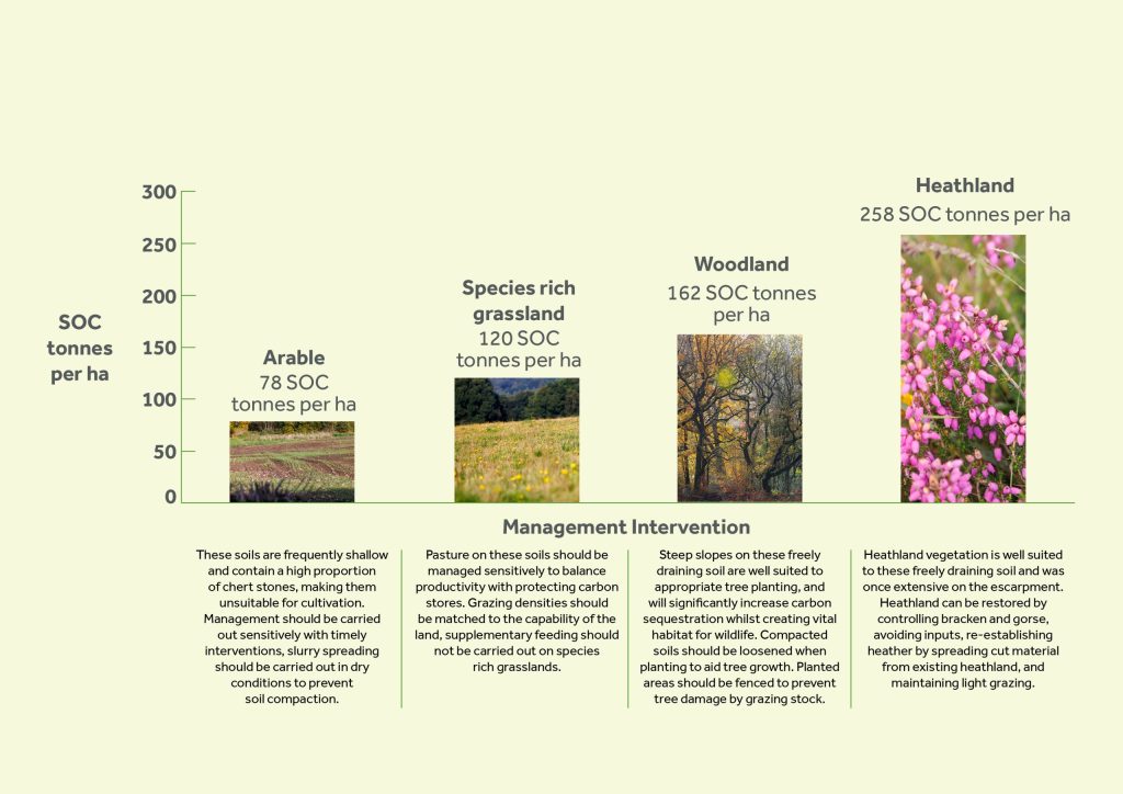
These figures have been taken from the data collected on soils during the Blackdown Hills Soil Carbon Project. View the whole dataset.
Managing medium soils
This section highlights common management risks and practical actions for medium soils. The examples below show practices that can damage soil structure and carbon, and alternative approaches that help protect soil health and carbon stores.
Positive management practices
- Grazing densities should be matched to the capability of the land.
- Silage making and slurry spreading should be carried out in dry conditions.
- In arable or ley rotations soils should be loosened after harvest to remove compaction and reduce risk of run-off.
- Early maturing varieties of maize should be chosen to enable a September harvest to allow groundwork to be carried out in dry conditions.
- Maize should not be grown on soils that lie wet for long periods.
- Drainage maintenance allows better access to and more timely use of land, but wetland habitats should not be drained.
Negative management practices
- High risk of compaction, poaching and waterlogging.
- High risk of erosion and oxidation.
- Travelling on these soils when wet will lead to compaction.
- Spreading slurry in winter causes compaction when soils are wet leading to run-off.
- Late drilling of crops after maize makes compaction worse. Poor crop cover through the winter causes run-off and pollution of watercourses.
- Degraded soil structure and reduced porosity produces run-off and erosion. Sediment in run-off causes water pollution.
- The poorly drained Dunkeswell soils are often wet for much of the year making them very vulnerable to compaction, waterlogging and erosion.
Opportunities for carbon sequestration on medium soils
This section highlights potential opportunities to protect and increase soil carbon for medium soils, based on different land uses and management approaches observed locally.
These figures have been taken from the data collected on soils during the Blackdown Hills Soil Carbon Project. View the whole dataset.
Managing heavy soils
This section highlights common management risks and practical actions for heavy soils. The examples below show practices that can damage soil structure and carbon, and alternative approaches that help protect soil health and carbon stores.
Positive management practices
- These slowly-draining soils are suited to livestock pasture but grazing densities should be matched to the capability of the land.
- Grazing and vehicle use should be avoided in late autumn, winter and spring.
- Slurry spreading should be carried out in dry conditions in summer to prevent soil compaction and support abundant earthworms.
- Drainage measures such as subsoiling and moling above land drains covered by gravel help improve water movement through the soil and reduce risk of compaction.
- Drainage maintenance allows better access to and a more timely use of land. Wetland habitats should not be drained.
- Wetlands to store flood water can be constructed. This can slow down run-off, stabilise soils and improve water quality.
Negative management practices
- Heavy soils are naturally surface-wet and do not absorb rainfall, especially in winter. They generate rapid run-off and erosion.
- Cultivation of heavy soils in spring causes compaction because subsoils lie wet even when topsoils appear friable at the surface.
- Soil compaction makes run-off worse. This can be the case even in permanent grassland whereby moderately permeable topsoils stop absorbing water.
- Vulnerable to compaction when they are moist: avoid out-wintering stock or establishing seedbeds late in the year.
- Maize should not be grown on heavy soils as they naturally lie wet for long periods and it is difficult to harvest without damaging the soil.
- Spreading slurry in winter causes compaction when soils are wet leading to run-off from damaged fields.
Opportunities for carbon sequestration on heavy soils
This section highlights potential opportunities to protect and increase soil carbon for heavy soils, based on different land uses and management approaches observed locally.
These figures have been taken from the data collected on soils during the Blackdown Hills Soil Carbon Project. View the whole dataset.
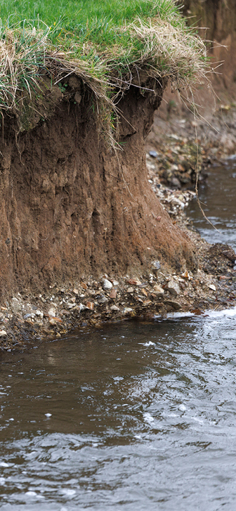
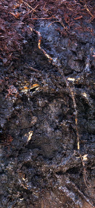
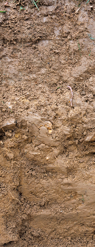
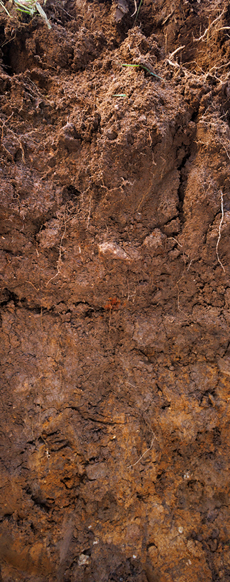
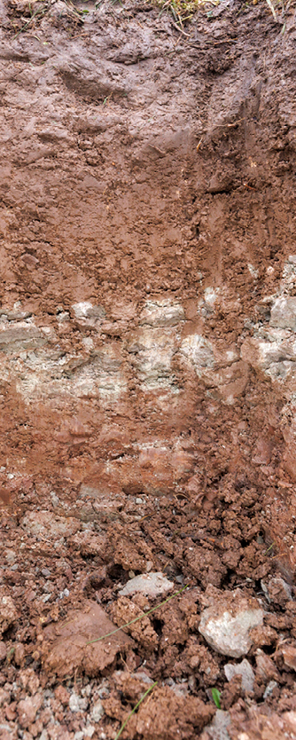
Soil profiles
These soil profiles bring together the final stage of this guide, showing what different soils in the Blackdown Hills look like below the surface and how their structure, drainage and organic layers influence soil condition and carbon storage. Use these profiles to help confirm which soils you have and to understand how management choices affect soil health over time.
- Blackdown agricultural
- Blackdown semi-natural
- Dunkeswell
- Batcombe
- Bearsted
- Hense
- Whimple
- Evesham
- Fladbury
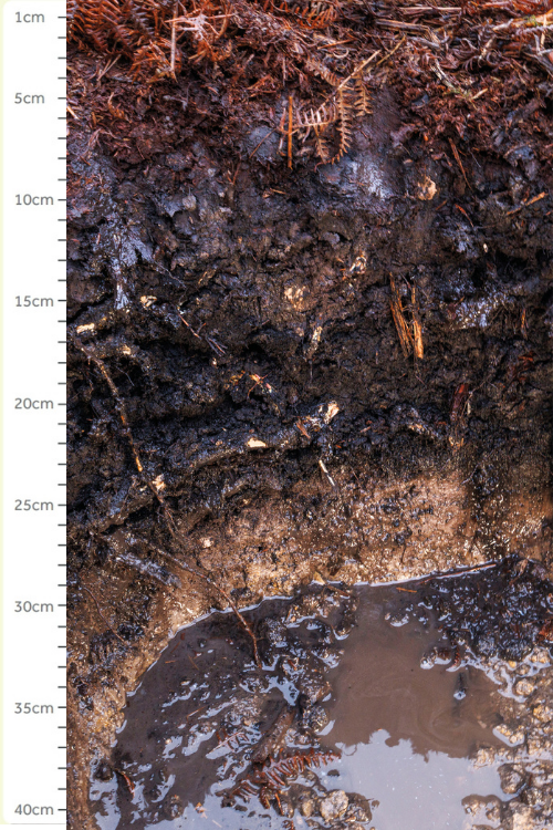
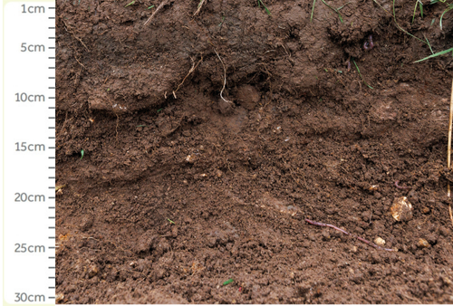
Soil profile 1: Blackdown (agricultural profile)
A poorly drained peaty soil, unique to the landscape of the Blackdown Hills and East Devon plateau.
Characteristics and land use
- Seasonally waterlogged, slowly permeable soil with black peaty top soil.
- Wetness and weak bearing strength means it has limited agricultural capacity.
- Some areas of arable and grass.
- Often planted with conifer woodland.
- A few remnants of previously extensive heath and deciduous woodland.
- High potential to sequester carbon through reversion to wet heath or woodland.
192
Average SOC tonnes per hectare
(taken from all existing data).
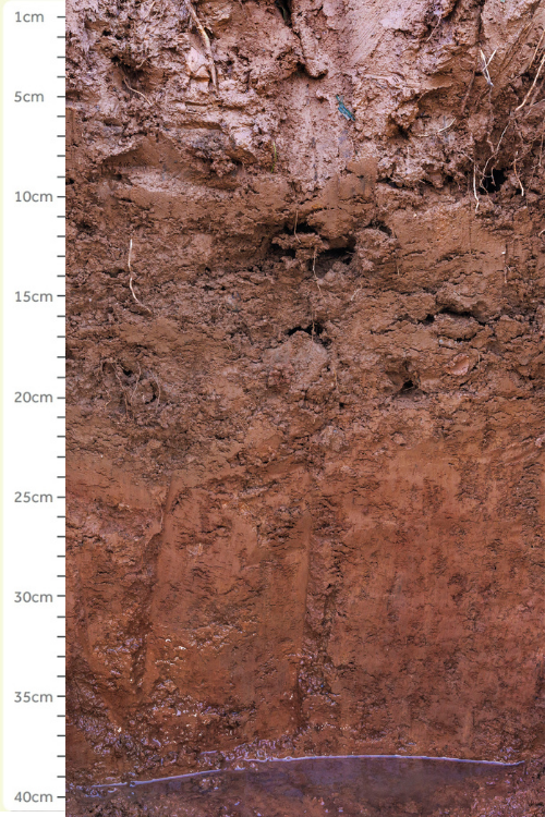
Soil profile 1: Blackdown (semi-natural profile)
A poorly drained peaty soil, unique to the landscape of the Blackdown Hills and East Devon Plateau.
Characteristics and land use
- Seasonally waterlogged, slowly permeable soil with black peaty top soil.
- Wetness and weak bearing strength means it has limited agricultural capacity.
- Some areas of arable and grass.
- Often planted with conifer woodland.
- A few remnants of previously extensive heath and deciduous woodland.
316
Average SOC tonnes per hectare
(taken from all existing data).
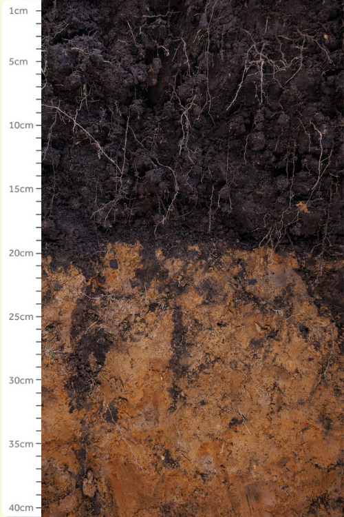
Soil profile 2: Dunkeswell
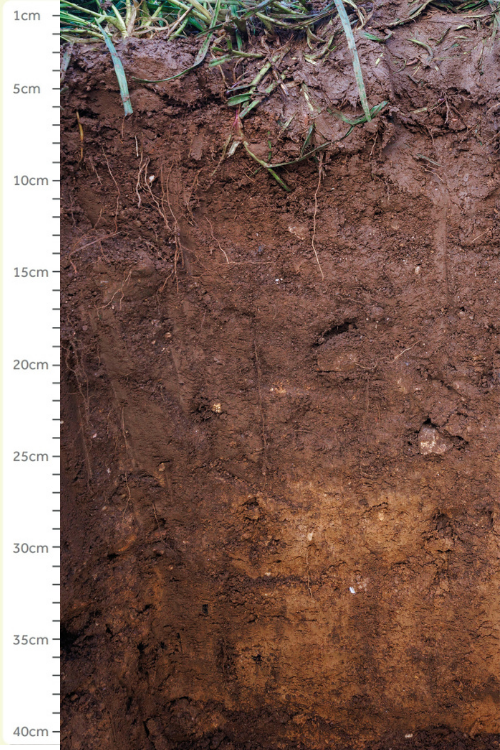
Poorly drained medium brown soil found across the plateau.
Characteristics and land use
- Poorly drained, slowly permeable soil, very similar to Blackdown soils but lacking the peaty surface horizon.
- Dairying on short term and permanent grassland, or cereals; some coniferous woodland and wet heath.
- Vulnerable to waterlogging, compaction, poaching and erosion.
- Very few areas of semi-natural vegetation remaining on these soils. Similarities to Blackdown soils means there is a high potential to sequester carbon through reversion to wet heath or woodland.
155
Average SOC tonnes per hectare
(taken from all existing data).
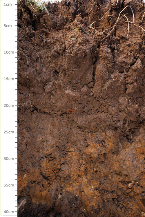
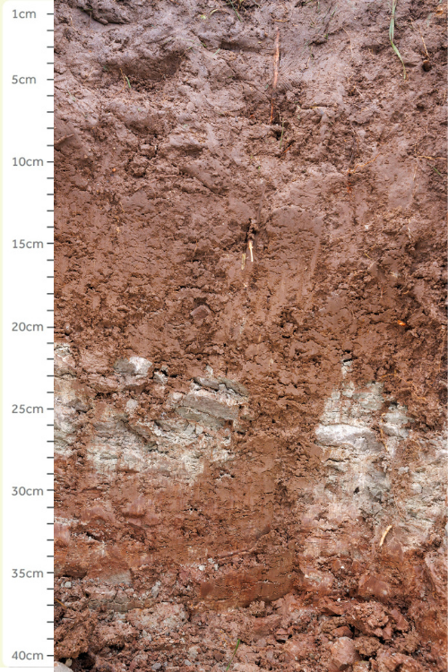
Soil profile 3: Batcombe soil
A medium brown soil with the second largest area in the landscape, found across the plateau. Poorly drained medium brown soil found across the plateau.
Characteristics and land use
- Moderately well drained, driest and most productive of the plateau soils.
- Cereals, permanent grassland and dairying.
- Weak soil structure makes it vulnerable to compaction, poaching and erosion.
- Very few areas of semi-natural vegetation remaining but woodland is common on these soils in other areas.
145
Average SOC tonnes per hectare
(taken from all existing data).
Soil profile 4: Bearsted soil
A well-drained coarse/sandy loam soil found across the steep escarpment of the Blackdown Hills.
Characteristics and land use
- Freely draining, light soils with black humose top under semi-natural vegetation.
- Can be very shallow and sandy, or stony in places, meaning it has limited agricultural capacity.
- Large areas of grassland and small areas of arable.
- Some areas of woodland or heath on the steepest land.
- Under areas of historic dry heath there are humose black podzol soils, these have higher levels of soil carbon and have good potential for heathland restoration .
163
Average SOC tonnes per hectare
(taken from all existing data).
Soil profile 5: Hense soil
A humose or peaty soil, affected by
ground water, found extensively across
the springline of the landscape.
Characteristics and land use
- Seasonally waterlogged by groundwater.
- Wetness and weak bearing strength means it has limited agricultural capacity.
- Where drained, used entirely as permanent pasture.
- Where undrained, supports wet heath, springline mire or wet woodland.
- Stores the most carbon per ha in the landscape.
813
Average SOC tonnes per hectare
(taken from all existing data from semi-natural profiles).
180
Average SOC tonnes per hectare
(taken from all existing data from agricultural profiles).
Semi-natural profile
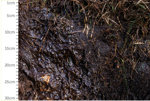
Agricultural profile
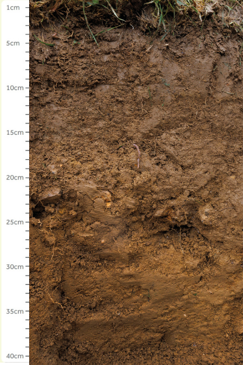
Soil profile 6: Whimple soil
A medium reddish-brown soil with the largest area in the landscape and found across the vales.
Characteristics and land use
- Moderately well drained, driest and most productive of the vale soils.
- Almost entirely in agricultural use, has good nutrient reserves from underlying mudstone, mostly used for dairying with some areas of arable and ley.
- Can lie wet for long periods during winter, and so are vulnerable to compaction in spring when they have not dried out.
- Very few areas of semi-natural vegetation, but significant increases in soil carbon found under species rich grassland.
133
Average SOC tonnes per hectare
(taken from all existing data).
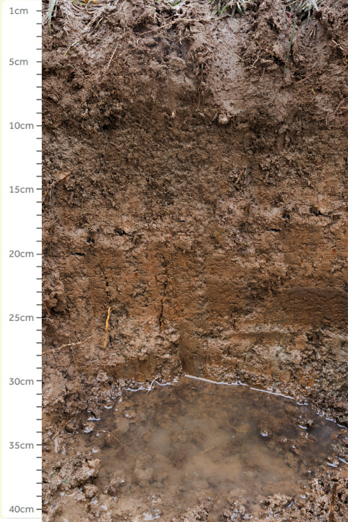
Soil profile 7: Evesham soil
A poorly drained fine loamy soil found in the vales to the north and east of the landscape.
Characteristics and land use
- Seasonally waterlogged due to heavy clay subsoil.
- Wetness and weak bearing strength means it has limited agricultural capacity.
- Calcareous subsoil.
- Predominantly permanent pasture, with some areas of arable.
- Very few areas of semi-natural vegetation, but significant increases in soil carbon found under species rich grassland
159
Average SOC tonnes per hectare
(taken from all existing data).
Soil profile 8: Fladbury soil
An alluvial gley soil found throughout the flood plains adjacent to the rivers Culm, Otter and Yarty.
Characteristics and land use
- Slowly permeable, often seasonally waterlogged by ground water.
- The key risk is periods of inundation during winter, this limits agricultural capacity due to the wetness of the soil and risk of poaching.
- Rushes are common on the wettest sites.
- Large areas of permanent pasture or long-term leys.
- Being on the flood plain, it could support riparian woodland or wet grassland.
152
Average SOC tonnes per hectare
(taken from all existing data).
Soil Toolkit text and project management by Fred Constantine Smith, supported by Gavin Saunders, for Blackdown Hills National Landscape. Thanks to Richard Smith for advice and support. Photography Paul Box.
Footer Navigation
Widget


Widget